ENSO is a disruption of the ocean-atmosphere system in the tropical Pacific such that coastal upwelling off the Peruvian coast decreases or stops. This results in a warming of the surface water off Peru that can spread across the Pacific ocean. The warm sea surface allows for rain in the normally dry coastal regions of Peru.
|
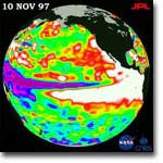
ENSO
event
|
"Normal"
|
 |
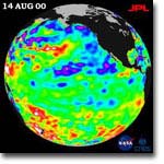 |
(www.pmel.noaa.gov/tao/elnino/nino-home.html; www.coaps.fsu.edu/lib/climatoons)
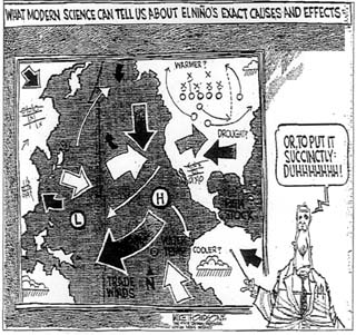
(cartoon courtesy of Center for Ocean-Atmospheric Predictions Studies)
WHAT HAPPENS?
During an ENSO event, changes occur in the composition of the water along Peru's coast. These include:
- increased sea surface temperature; cold coastal water confined to narrow band along the shore
- salinity decreases (possibly due to increased rain)
- changes in the types of phytoplankton; more warm water phytoplankton species appear
- reduction in nitrogen and phosphorous concentrations at the surface (possibly due to decreased upwelling)
- decreases in primary production (possibly due to reduced nutrients)
In addition, the unusual torrential rain in Peru cascades into tremendous changes in weather patterns throughout the world with adverse effects on humans and ecosystems. For example, the 1982-83 ENSO resulted in the following unpleasant events:
- Australia - Drought and bush fires
- Indonesia, Philippines - Crops fail, starvation follows
- India, Sri Lanka - Drought, fresh water shortages
- Tahiti - 6 tropical cyclones
- South America - Fish industry devastated
- Across
the Pacific - Coral reefs die
- Colorado
River basin - Flooding, mud slides
- Gulf
states - Downpours cause death, property damage
- Peru,
Ecuador - Floods, landslides
- Southern Africa - Drought, disease, malnutrition
(seawifs.gsfc.nasa.gov/OCEAN_PLANET/HTML/oceanography_el_nino.html)
-
How can increased rain in one location, Peru for example, induce such dramatic meteorological activities worldwide?
- How do you think this change affects the organisms in the ecosystem?
WHEN HAVE THEY OCCURRED?
An ENSO event was first reported in the scientific literature in 1891 by the Lima Geographical Society. These geographers reported on the unusual torrential downpour from February to April on the desert, coastal region of Peru, and the abnormally warm waters along the coast running from north to south. They were the first to make the link between these exceptional precipitation and warm coastal waters.
Further investitation into weather archives for the previous 100 years revealed that there had been 10 other years with heavy rains and coastal warming within the last century (1790, 1804, 1814, 1828, 1845, 1864, 1871, 1877, 1878, 1884, 1891). All of these events began in December. This led to the naming of these exceptional rain occurrances, El Nino (i.e. the Boy in Spanish), in reference to the infant Jesus Christ.
ENSO events reported within the 20th century occurred in:
|
|
|
| bold years = high-intensity events | ||
- Were there any major ecological activities taking place off the Peruvian coast during the ENSO years in the 20th century?
- Could the ENSO events have affected these activities? How?
(Open University Course Team, 1989; Voituriez, 2000; Vondruska, 1981)
HOW DOES IT WORK?
During normal conditions, the coastal upwelling off the Peruvian coast creates a westward flow of warm sea surface water. This causes a pile up of warm water in the western Pacific resulting in higher sea level off the Indonesian east coast compared to the Peruvian west coast.
The warm surface water evaporates providing moisture for the air in the western Pacific. The warm, moist air rises, creating a low pressure system (the Indonesian Low) and regular rainfall in Indonesia. The dry air moves east, cools and then sinks in the eastern Pacific. This creates a high pressure system (the South Pacific High) and a dry climate in Peru.
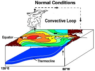
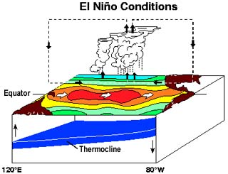
Every two to seven years, the southeast tradewinds blowing across the Andes lessen. This weakens or eliminates the offshore deflection of surface water off the Peruvian coast. Consequently, Peru's coastal upwelling is minimized. The sea surface water remains off the coast of Peru, and thus warming the coastal water.
Remember, sea level was slightly higher in the western Pacific due to the westward flowing surface water. Since that is now eliminated, the warm surface water moves east in order to equilibrate its height. Consequently, the eastward movement of warm sea surface water across the southern Pacific further warms the Peruvian coastal water. The warm surface water in the eastern and central Pacific evaporates and forms rain clouds.
Movement of rainfall from the western Pacific to the eastern Pacific alters the atmospheric moisture content in these areas. The global repercussions to such a change can be very dramatic.
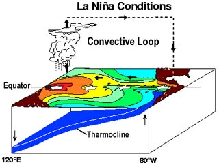
La Nina exists when
- extreme cold sea surface temperatures appear in the central and eastern equatorial Pacific for an extended period of time,
- westward blowing winds along the equator are strong,
- the thermocline is depressed in the western Pacific, but near the surface in the eastern Pacific,
- sea level drops in the western Pacific drops and rises in the eastern Pacific.
La Nina is less well understood and studied than El Nino. This is partly a result of the less frequent occurance of La Nina events. Scientists speculate that the impacts of La Nina are generally opposite to those of El Nino.
(www.pmel.noaa.gov/tao/elnino/nino-home.html; Glantz, 2001)
-
Examine the diagram for El Nino conditions, how do you think this change affects the coastal upwelling in Peru?
-
How do you think El Nino or La Nino events affect the anchovy fishing industry?
This web site was created by Lynn Tran at the North Carolina State University, Department of Mathematics, Science, and Technology Education on 7/12/03. Faculty advisor Dr. David Eggleston, NCSU, Department of Marine, Earth, & Atmospheric Sciences. Last updated December 29, 2003 .